Peak(s): Vestal Peak and Arrow Peak
Elevation(s): 13,864ft – 13.803ft
Date Climbed: 9/10/2016
Getting There
There are more then a few options to access Vestal basin, but I’ll cover the two most traveled.
Option 1
You can take the train out of Durango or Silverton to the Elk Park stop and hike in via the Colorado Trail. If you haven’t ever taken the Durango & Silverton Narrow Gauge Railroad I’d advise to take this option. It’s an awesome experience and allows you a glimpse into the Weminuche Wilderness from the comforts of a train car.
Option 2

Head north out of Durango on highway 550 for 43 miles towards Molas Lake. There is a pullout just south of the turn for Molas Lake. There will be a brown sign reading “Molas Pass and Molas Park”. Turn here and follow the dirt road until you come to a large dirt parking lot, park here. Take the Colorado Trail from the parking lot and head southeast towards the Animas River and the D&SNGR train tracks (3 miles). Once you reach the tracks head south until you find the Elk Creek/Colorado Trail. This is your trail up to the Beaver Ponds. Option 2 adds roughly 3 miles both ways and a 1’700ft climb on your hike out, but on the flip side saves you about $100 on a train ticket. So if you’re strapped for cash like me, then this is the more viable option.
Both options will take you east on the Colorado Trail towards the Beaver Ponds (~3 miles). Once to the beaver ponds, work your way around to the east side of the ponds where the trail splits and heads south (look for cairns). Boulder hop your way to the south side of the ponds where the trail becomes apparent again and heads southeast. This trial is more of a climbers trail and is not well maintained. With lots of downfall, hiking the remaining 3 miles into Vestal Basin is a workout.
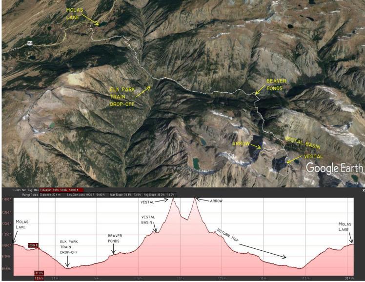
The photo below shows our hike in from Molas Lake as well as the drop-off from the train – click to enlarge.
Camping
There are several sites on the north and southeast sides of the Beaver Ponds, as well as several dispersed sites on the eastern end of Vestal Basin. Vestal Basin is in the Weminuche Wilderness and all wilderness camping restrictions apply. Please respect the restrictions and keep this place and all other wilderness areas pure. Pack it in/pack it out.
A Weekend in the Grenadiers
A few months prior in July, a group of friends and I spent four days backpacking the Weminuche Wilderness and unfortunately ran into a bit of rain, which stymied our hopes of summiting several of the Wemi’s peaks. Vestal Peak was one of those peaks. Fast forward two months and Eric, Lauren and I had rescheduled a date with Vestal.

Friday
I dipped out of work a little early on Friday and met Eric and Lauren at my house in Durango to carpool to the trailhead. We arrived at Molas Lake around 3pm and set off for Vestal Basin at about 3:30pm. The Colorado Trail switchbacks southeast from Molas Lake loosing elevation until it meets with the Animas River at about 9,000ft. From here, a footbridge crosses the Animas River and heads south along the railroad tracks, eventually turning back east and angling up towards the Beaver Ponds.
As we crossed the river and walked next to the tracks I saw a big brown object moving towards us out of the corner of my eye.. I snapped my head around just in time to see a medium sized cow moose and her calf walking directly down the middle of the train tracks. What a way to start a trip! Although this scared the bejesus out of me, it was pretty exciting. This wasn’t the last we’d see of that momma moose and her calf.
Four hours later and we had reached the Beaver Ponds. The sun had just dropped behind the hills and darkness was beginning to set in. We started a fire, ate dinner and rolled up in our sleeping bags for a 6am wake up call.
Saturday – Vestal Peak (Wham Ridge)

Saturday morning came as all early mornings in the mountains do.. Cold and fast. Breakfast. Coffee. Gear packed. Time to go. Lauren unfortunately wasn’t feeling well, so she packed up and headed back to the car. The climb up to Vestal Basin is not a pleasant one, but is a necessary evil to gain access to this amazing place. Let the pain become your friend and you’ll quickly begin to enjoy your time in the mountains.
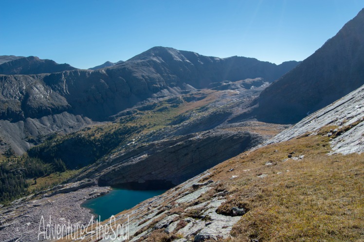
Once into the basin there is a serious bushwhacking/slog fest in store. The undergrowth surrounding the trail will leave you soaking wet if you hit it early in the morning, or right after a rain, so be prepped to get wet. The trail heads east further up into the basin before turning south and crossing Vestal Creek. The next challenge is climbing to the upper basin. A steep 800ft headwall keeps you from the base of Vestal’s prominent north face. Time to put your head down and start grinding. This final push before you gain the base of Vestal Peak is over as quickly as it begins and it’s time to focus in on the climb ahead.
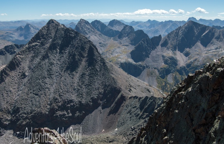
As we crested the headwall and entered the upper basin, Vestal Peak and the iconic ramp began to dominate our field of view. Wham Ridge stared down on us, challenging us to continue on and climb. Not one to back down from a challenge, we pressed on.
The surrounding peaks of the Grenadier range dominate the landscape with impressive, granite walls, rising up and touching the heavens.
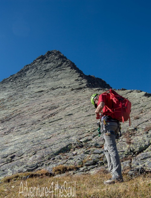
The Climb
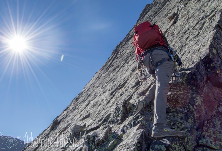
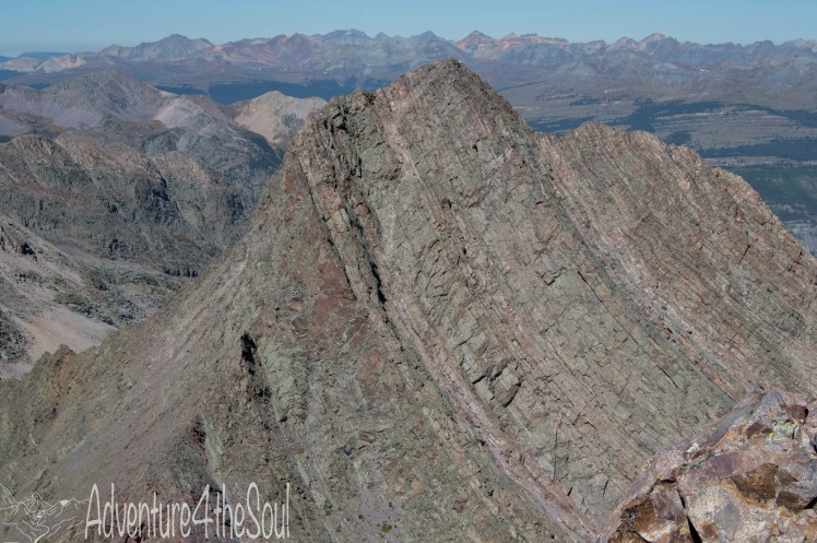
The ramp of Vestal Peak is at a gentle enough slope to free climb with little consequence for the first couple hundred vertical feet. After that it begins to steepen up and the consequences become a little more severe. We decided to rope up at one of the last grassy ledges before the face turned to sheer granite and the climbing difficulty increased. Wham Ridge lay ahead of us ready for the taking.
With both of us tied into either end of the rope, we started up. Eric lead the entire climb. He would place cams and/or nuts and I would follow roughly 20-30 feet behind pulling gear as we simultaneously climbed. Every now and then I would climb up to Eric and hand over the gear I had accumulated and we would continue on. We did this for the better part of an hour as we worked our way up the solid, 4th class ridge. For the most part, the ridge stays class 4, however, there are a few 5th class moves along the way. We jumped back and forth from the ridge to the face, keeping the route interesting. The higher you get on the ridge, the looser the rock becomes. Eventually the face starts to break apart and you find yourself scrambling between loose rock/dirt shelves. The holds are mostly solid, but test everything anyways.


It took us about 90 minutes from the base of Vestal’s north face to climb up to the summit. Total time from our camp at the Beaver Ponds was roughly 4.5 hours. The views of the San Juans from almost 14,000ft. is something that I’ll never forget. I’m a lucky man to be able to call this place my backyard.


After grabbing a quick snack and discussing our options for the day, we decided to head down and make moves towards Arrow Peak. We had originally planned to attempt the Trinities after summiting Vestal, but decided that plan was a little overly ambitious and being that we would be hiking from west to east and still have to backtrack our way back to the Beaver Ponds… Maybe next time.
The route off of Vestal can be an exhausting, soul-crushing descent if you pick the wrong route down. Head southeast off the summit towards an obvious south facing couloir. Be careful not to drop off the east towards the West Trinity/Vestal saddle. Stay in the large south facing couloir for a couple hundred feet then look for your exit back to the west. There is a cairn and a faint trail leading out of the couloir. This trail cuts back west across Vestal’s south side and wraps around to the Arrow/Vestal saddle. There is no going around the nastiness that lies ahead. Boot ski/butt slide your way down the loosest crap in the San Juans. This section reminded me of Lavender Col. on Mt. Sneffels standard route but steeper and way less fun. Carefully descend this section, as you can and will send rocks trundling down below you and onto some poor saps head, more than likely ruining his day.
Saturday – Arrow Peak (Northeast Rib)
After having successfully summited Vestal Peak, and with the stoke level on high, we made moves over to Arrow Peak.
It was about 1pm at this point and the weather gods had blessed us with the clearest blue bird day I’d ever seen in the San Juans. Sometimes the weather gods smile down on you, and sometimes they don’t, and after having been rained out on our last trip to the Wemi, the nice weather was a blessing. We grabbed a quick bite, stashed our climbing gear, and started the long haul up the northeast ramp.

The ramp on Arrow seemed eerily similar to the ramp of Vestal. The smooth granite gradually gets steeper the higher you get. The route finding is fairly straight forward for the first 1,000ft or so, but becomes trickier the higher you get. At one point the ramp you are on steps up to an upper ramp to your right (west). Take the upper ramp, but hang to the left (east) side and out of the gully to the right. Your goal here is to gain the rib on the left side of the gully (northeast rib). The climbing on the east side of this rib is solid class 4 scrambling, and the route is fairly well marked. The route kicks you back out onto the face of the rib and leads to the saddle between Arrow and North Arrow, at which point you’ll head left towards the summit.

Having two classic climbs under our belt on a beautiful day in the San Juans, the stoke level was off the charts! Not to mention we had both summits to our selves, and the weather was perfect. At the summit we did some partying, snarfed some grub, high-fived and took in the views. This place is so damn special. Time to make moves back down to the Beaver Ponds to hang with the beavers.
We arrived back at our camp at about 6pm, bringing our epic 12 hour day to an end. Dinner. Whiskey. Sleep.

Sunday
7am. Time to pack up camp and head for Molas Lake. As we were hiking down from the Beaver Ponds, our momma moose buddy and her calf showed up again, but this time brought the poppa bull moose along. These three majestic animals were 40ft away from Eric and I. The bull moose was standing directly on the trial and the cow and calf were about 50ft off trail. We stood and watched for a minute or two as the bull slowly walked towards the other two. With the bull off the trail, we slowly hiked past. The bull never took his eyes off of us as we passed. Man, could we get any luckier? Two up close and personal moose encounters in one trip. It was pretty amazing seeing these animals that close. Bummed I didn’t get any pictures..
The rest of the hike back to Molas Lake was long and uneventful. Hiking the switchbacks out of the Animas River valley is a chore, but the two days we spent in the Grenadiers was worth every painful step.

Resources and Trip Reports
Vestal Peak
http://www.summitpost.org/vestal-peak/151812
Arrow Peak

Amazing places!
And very interesting blog!
LikeLiked by 1 person
The San Juan range is an incredible place. Thanks for reading!
LikeLiked by 1 person
Hi, we were on your site looking for a contact page, but there was none. Do you have an email we can reach you through? We’d like to explore some collaboration ideas with you. Maybe we could interview you, or you can do a guest post that links back to your page. We’re always looking for avid outdoor adventurers and we like to publish original content. Reach out, thanks.
LikeLike
Hey C.J. – thanks for reaching out. I sent you a message through the contact form on your site. You can reach me at rrupe0923@gmail.com. Looking forward to hearing from you.
LikeLiked by 1 person
Thank you. We’ll check it now.
LikeLike
We saw that you got the invite, just wanted to double check that you received the email as well. Cheers, -C.
LikeLike
Got the email and am excited to start working on something to share on your site. Cheers.
LikeLiked by 1 person